
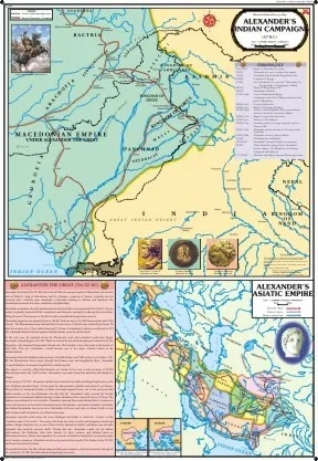
Alexander's Indian Campaign (70x100)
Description
The “Alexander's Indian Campaign (70x100)” is a large-format educational wall map that illustrates Alexander the Great’s military expedition into the northwestern Indian subcontinent from 327–325 BCE, a landmark event connecting Greek and Indian civilizations.
Physical Specifications
Size: 70 × 100 cm, suitable for classrooms, library displays, and history exhibits.
Material: Multicolour printing on 80 GSM map litho paper, thermally laminated with 30-micron polyester film, and fitted with quality plastic rollers to hang.
Languages: Available in English, Hindi, Kannada; certified for educational accuracy by Survey of India.
Map Content & Educational Value
The chart maps Alexander’s route: entry from the northwest through the Hindu Kush, crossing the Indus near Attock, advance to Taxila, and the sequence of battles and conquests in Punjab and Sindh.
Major milestones include:
The surrender of King Ambhi (Taxila) without conflict.
The Battle of Hydaspes (Jhelum River, 326 BCE) against King Porus, one of Alexander’s costliest but most significant victories.
The campaign along the five rivers of Punjab, movement to the Hyphasis (Beas River), and the mutiny of Macedonian troops which halted further eastward expansion.
The retreat down the Indus, including operations in Sindh and the crossing of the harsh Gedrosian desert en route to Babylon.
Landmarks and ancient cities (Taxila, Jhelum, Beas, Patala, Gedrosia) are highlighted, as well as boundaries with contemporary Indian polities (Pauravas, Nanda Empire).
Notes may describe the interaction between Greek and Indian cultures, aftermath of the campaign (Greek settlements, Indo-Greek kingdoms), and lasting diplomatic, artistic, and scientific influence.
Historical Context
Alexander’s campaign marks the first significant direct contact between India and the Hellenistic world, with profound influence on art, urbanism, and cross-cultural exchange.
The chart situates the campaign within the context of Persian and earlier Achaemenid expansions and the formation of Indo-Greek kingdoms after Alexander’s departure.
An essential educational resource for visualizing ancient military routes, landmark battles, and the interconnected history of Eurasia.
This wall map is ideal for teaching the historical geography and significance of Alexander’s Indian expedition, highlighting routes, battles, and cultural legacy.
Specifications
| Model No. | N-C232 |
|---|


