
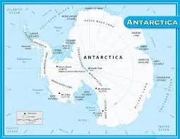
Antarctica Physical Map (100x70cm)
Description
The label “Antarctica Physical Map (100x70cm)” refers to a large-format educational wall map that highlights the physical geography of Antarctica, formatted for classroom or laboratory display at 100×70 cm.
Map Content Overview
Title: Antarctica Physical Map
Size: 100×70 cm (ideal for display and detailed study)
Key Map Features:
Representation of the continent’s outline with ice shelves, glaciers, and major physical features
Topographic relief to show elevation differences (mountains, valleys, plateaus)
Named features: Transantarctic Mountains, Antarctic Peninsula, Ross Ice Shelf, Ronne Ice Shelf, Mount Erebus, and other major landmarks
Major research stations (e.g., McMurdo, Amundsen-Scott, Vostok)
Ocean labels (Southern Ocean) and coastal boundaries
Ice flow directions, glaciated regions, and exposed rock outcrops
Color coding or shading to indicate regions of high ice thickness versus exposed terrain
Educational Use
Used in geography and earth science classrooms to teach about polar environments, glaciation, and climate features.
Designed for high legibility, clear contour lines, and accurate placement of major geographic features.
For a print-ready map:
Employ high-resolution vector or raster formats to ensure clarity at large display sizes
Include a legend/key for physical features and topographic symbols, with scale and orientation for reference
For more specialized requirements (e.g., addition of research stations, geological labeling, lamination details), please specify so that customized design advice may be provided.
Specifications
| Model No. | N-C117 |
|---|


