
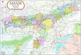
Assam Political Map (70x100cm)
Description
A political map of Assam in the 70×100 cm format is widely available through Indian educational suppliers and online retailers, suitable for classrooms, offices, and professional exhibition spaces.
Product Specifications
Size: 70×100 cm (also listed as 100×70 cm by various vendors).
Material: High-quality laminated paper, multicolour print for durability and clarity.
Languages: Available in English and Assamese.
Features:
Survey of India certified for boundary and administrative accuracy.
All district and subdivision boundaries, major towns, cities, rivers, highways, and capitals are shown.
80 GSM Map Litho paper, thermally laminated on both sides with polyester film for tear-resistance and water-resistance.
Download and Print Options
High-resolution Assam state maps (JPG, PNG, WEBP, PDF) suitable for 70×100 cm printing can be directly downloaded from websites like MapInside.in and MapsofIndia.com.
Digital files offer pixel resolutions adequate for sharp large-format prints.
Ordering and Customization
Orders can be placed for single pieces or bulk sets via vendors and educational catalog suppliers.
Customizations may be available for schools or organizations requiring extra marking for specific features (districts, capitals, etc.).
These Assam political wall maps are widely used for educational, administrative, and reference purposes, and meet quality standards for clarity, accuracy, and display longevity.
Fitted with rollers and hanging arrangements for easy display.
Specifications
| Model No. | N-C330 |
|---|


