
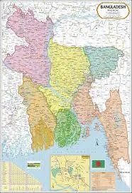
Bangladesh Map (70x100)
Description
The “Bangladesh Map (70x100)” is a large-format educational wall map displaying the country of Bangladesh, its divisions, regions, and major cities, designed for classroom, study, or office display at 70×100 cm.
Map Content Overview
Title: Bangladesh Map
Size: 70×100 cm (ideal for detailed regional and educational reference)
Key Map Features:
Clear outline of Bangladesh’s international borders, neighboring India and Myanmar, and featuring the Bay of Bengal
Administrative divisions labeled and color-coded: Dhaka, Chattogram, Khulna, Rajshahi, Rangpur, Sylhet, Barisal, Mymensingh
Major cities and towns: Dhaka (capital), Chattogram, Khulna, Rajshahi, Sylhet, Barisal, Mymensingh, Rangpur, Comilla, Narayanganj, Jessore, Bogura, Tangail, etc.
Primary rivers shown: Padma (Ganges), Jamuna (Brahmaputra), Meghna, Teesta, Surma, Karnaphuli
Physical features: Sundarbans mangrove, hill tracts, key national parks, and the deltaic plain
Highways, railways, seaports, and airports for transport reference
Educational Use
Used in geography, social studies, environment, and development studies for learning about Bangladesh’s regions, cities, and natural features.
Designed for clear classroom visibility, division boundaries, and bold, readable labels for teaching purposes.
For printing:
Use a high-resolution map with strong color distinction and clear city labels
Can be customized for overlays (physical/political, population, language, transport), bilingual features, or additional detail as required.
Specifications
| Model No. | N-C159 |
|---|


