
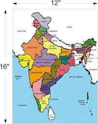
India Political Map (100x140cm)
Description
The “India Political Map (100x140cm)” is an extra-large, detailed educational wall map designed to display India's states, union territories, capitals, major cities, boundaries, and other significant features, making it ideal for classrooms, offices, and geography instruction.
Description
Size: 100 × 140 cm, classified as “jumbo size,” providing extra clarity for group viewing and teaching.
Material: Printed on high-quality, durable paper with double-side lamination to protect against scratches, dust, and moisture.
Mounting Options: Typically supplied without PVC rollers but includes double-sided tape on the back for easy installation on walls or boards.
Content Features:
Clearly delineates all state and union territory boundaries, national and state capitals, major cities, highways, rivers, mountain ranges, and important geographic markers.
Accurate as per recent administrative boundaries and suitable for both English and Hindi medium education settings.
Some versions provide information on population density and other demographic or economic features for added learning value.
Language and Usability: Available in both English and Hindi; designed for use in Indian schools as well as for general geographic reference.
Educational Value
Acts as a reference tool for teaching Indian geography, civics, and current affairs in classrooms and study centers.
Facilitates easy visual learning of states, capitals, neighboring countries, and the structure of India's federal territories.
Useful for exam preparation, project work, and developing spatial awareness among students and learners of all ages.
This map is strongly recommended for any setting where comprehensive geographic reference or instruction on India’s political divisions is required.
Specifications
| Model No. | N-C202 |
|---|


