
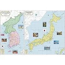
Japan-North Korea-South Korea Map (70x100)
Description
The “Japan-North Korea-South Korea Map (70x100)” is a large-format educational wall map covering the countries of Japan, North Korea, and South Korea, suitable for classroom, library, or office display at 70×100 cm.
Map Content Overview
Title: Japan-North Korea-South Korea Map
Size: 70×100 cm (ideal for regional detail and visual clarity)
Key Map Features:
Outlined boundaries for Japan (with prefectures), North Korea, and South Korea (with provinces)
Major cities: Tokyo, Osaka, Kyoto, Hiroshima (Japan), Seoul, Busan, Daegu (South Korea), Pyongyang, Hamhung (North Korea)
National capitals sharply marked: Tokyo, Seoul, Pyongyang
Major islands: Hokkaido, Honshu, Shikoku, Kyushu (Japan), Jeju (South Korea)
Sea of Japan (East Sea), Yellow Sea, Korea Strait labeled for orientation
Mountains, rivers, and physical features: Mount Fuji, Taebaek Mountains, Yalu River, Han River, Nakdong River
Notable geographic features: DMZ (demilitarized zone) between North and South Korea, important cultural regions (Kyoto, Gyeongbokgung area, etc.)
Educational Use
Utilized for teaching geography, history, East Asian studies, international relations, and travel planning.
Map designed for clear political, physical, and urban feature labeling for effective reference and group instruction.
For printing:
High-resolution scale and strong color contrasts recommended for classroom visibility
Customizable overlays for population, languages, historical events, transportation networks, or bilingual requirements as needed.
Specifications
| Model No. | N-C154 |
|---|


