
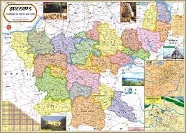
Jharkhand Physical Map (70x100cm)
Description
The “Jharkhand Physical Map (70x100cm)” is a large, laminated educational wall chart that illustrates Jharkhand’s physical features, including major landforms, rivers, plateaus, forests, and mineral resources. This map is widely used in classrooms, libraries, and for exam preparation.
Physical Specifications
Size: 70 × 100 cm, allowing clear, detailed presentation for classroom or group reference.
Material: Multicolour printing on quality art or map litho paper, with thermal lamination on both sides for durability and moisture resistance. Usually fitted with plastic rollers or loops for hanging.
Map Content and Features
Depicts the Chota Nagpur Plateau’s prominent uplands, valleys, and hill ranges, which dominate the landscape of Jharkhand.
Clearly marks the main rivers (Damodar, Subarnarekha, Koel, Brahmani, Barakar) and their basins, with associated major waterfalls and lakes.
Landforms include hills such as Parasnath, Rajmahal, Netarhat plateau, and important forest regions.
Shows state boundaries, district borders, neighboring states (Bihar, West Bengal, Odisha, Chhattisgarh, Uttar Pradesh), and prominent cities (Ranchi, Jamshedpur, Dhanbad, Bokaro) for orientation.
Highlights mineral-rich zones—Jharkhand is famous for coal, iron ore, mica, bauxite, and other resources—which are often indicated on physical maps given the state’s significance as a mining hub.
Includes wildlife sanctuaries and national parks: Betla National Park, Hazaribagh Wildlife Sanctuary, and Palamau Tiger Reserve.
Equipped with a legend, scale, and supporting notes for effective geography teaching and exam practice.
Classroom and Educational Use
Designed for lessons on landforms, rivers, natural resources, and geographic regions of Jharkhand.
Useful for map reading skills, environment and science projects, and competitive exam preparation (UPSC, state PSC, etc.).
The large format and lamination ensure the map’s durability and visibility for repeated classroom and group use.
This physical map provides an essential visual reference for understanding Jharkhand’s diverse and resource-rich geography.
Specifications
| Model No. | N-C314 |
|---|


