
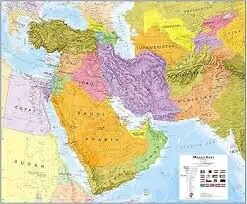
Middle East Map (70x100)
Description
The “Middle East Map (70x100)” is a large-format educational wall map representing the countries, cities, and major geographic features of the Middle East, designed for classrooms, libraries, and office environments at 70×100 cm size.
Map Content Overview
Title: Middle East Map
Size: 70×100 cm (excellent for group instruction and reference)
Key Map Features:
Outlined country borders: Saudi Arabia, Iran, Iraq, Israel, Jordan, Lebanon, Syria, Turkey, Egypt, United Arab Emirates, Qatar, Oman, Kuwait, Bahrain, Yemen, Cyprus, Palestinian Territories
Major cities labeled: Cairo, Riyadh, Tehran, Baghdad, Jerusalem, Istanbul, Dubai, Abu Dhabi, Doha, Beirut, etc.
Capitals highlighted for all countries
Key geographic features: Arabian Peninsula, Anatolian Peninsula, Levant, Persian Gulf, Red Sea, Mediterranean Sea, Tigris, Euphrates, Nile
Major highways, roads, railways, and ports
Insets or detail regions possible (e.g., Persian Gulf, Levant zone) for enhanced clarity
Educational Use
Used in geography, social studies, and contemporary history to teach Middle Eastern country locations, boundaries, and regional relationships.
Map designed for visual clarity, with strong boundary lines, bold labeling, and clear physical and political features.
For print:
High-resolution format and strong color contrast recommended for accurate demarcation
Optional customizations: language overlays, focus regions (oil, trade, religion), lamination, or labeling as required for specific teaching needs.
Specifications
| Model No. | N-C147 |
|---|


