
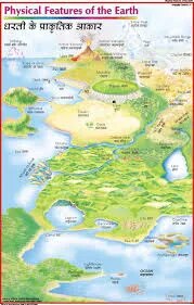
Physical Feature of Earth (50x70cm)
Description
The “Physical Feature of Earth (50x70cm)” poster is an educational wall chart depicting the major physical features found on Earth's surface, designed for geography and science classrooms at 50×70 cm.
Poster Content Overview
Title: Physical Feature of Earth
Size: 50×70 cm (suitable for classroom instruction and quick visual reference)
Key Visuals and Explanations:
Illustrated world map or sectional diagrams highlighting major physical features:
Continents and oceans
Mountain ranges (e.g., Himalayas, Rockies, Andes, Alps)
Plateaus, plains, and valleys (Great Plains, Amazon Basin, Tibetan Plateau)
Major rivers (Nile, Amazon, Yangtze, Mississippi), lakes, and deserts (Sahara, Gobi, Kalahari)
Coastal landforms: peninsulas, bays, capes, islands, estuaries
Polar ice caps, glaciers, volcanic regions, and tectonic boundaries
Separate infographics or callouts for each major landscape type, with labels and quick statistics or facts
Educational Use
Used in geography, earth science, and environmental studies to teach global landforms, water bodies, and earth system processes.
Poster designed for high visibility, concise labeling, and simple icons to aid recognition by students of all ages.
For printing:
High-contrast maps, color coding, and bold fonts recommended
Customization available for focused regions, bilingual content, or institutional branding.
Specifications
| Model No. | N-C167 |
|---|


