
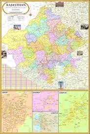
Rajasthan Political Map (70x100cm)
Description
Large-format Rajasthan political maps in the 70×100 cm size are widely available through educational and commercial suppliers, suitable for classrooms, libraries, and professional studies.
Product Specifications
Size: 70×100 cm (28×40 inches), ideal for wall display.
Material: High-quality paper, generally 90 GSM or 80 GSM, laminated on both sides (often with polyester film).
Language: Available in both English and Hindi versions.
Features:
Shows all current districts, state boundaries, and key cities and towns.
Certified for accuracy by Survey of India or equivalent official sources.
Bright multicolour printing ensures visibility and easy differentiation of regions.
Fitted with hanging arrangements or rollers for easy classroom installation.
Download & Print Options
High-resolution maps can be downloaded from reputable sites such as MapsofIndia.com and Vecteezy for custom printing at 70×100 cm size.
Educational suppliers often provide both laminated charts and downloadable PDFs/JPGs for institutional printing.Available individually or in bulk through educational map distributors, office supply retailers, and online stores like Meesho, Flipkart, IndiaMart, Bookswagon, and IBD Map House.
Pricing generally ranges between ₹110–₹150 for laminated charts; downloadable images and vector files may be free or nominally priced.
These wall maps meet standards for educational, competitive exam, and reference use, emphasizing clarity, district accuracy, and durable lamination for frequent handling
Specifications
| Model No. | N-C332 |
|---|


