
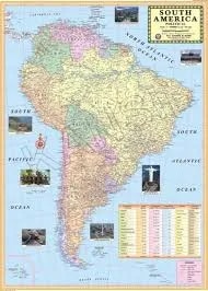
South America Political Map (100x70cm)
Description
The “South America Political Map (100x70cm)” is a large-format educational wall map depicting the continent’s political boundaries, countries, and capitals, ideal for classroom or laboratory display at 100×70 cm.
Map Content Overview
Title: South America Political Map
Size: 100×70 cm (best for detailed viewing and wall usage)
Key Map Features:
Clearly demarcated country boundaries with unique colors for each nation
All country names and capital cities labeled clearly
Major cities, rivers (Amazon, Paraná, Orinoco), and mountain ranges (Andes) for orientation
Neighboring countries and surrounding oceans (Atlantic, Pacific, Caribbean) labeled
Major lakes (Titicaca, Maracaibo, Poopó) and regional features shown
Regional territories (French Guiana, Falkland/Malvinas) marked as appropriate
Scale bar, compass rose, and clear legend for symbols and color coding
Educational Use
Widely employed in geography, history, and social science curricula for visualizing South American countries, capitals, and continental context.
Designed for color clarity, large readable labels, and easy recognition of political features in a classroom environment.
For print-ready use:
Opt for high-resolution or vector sources to maintain sharp boundary delineation and legible text at large scale
Legends and major city insets can be included to enhance utility
Customizations such as additional language labeling, topographic overlays, or lamination options are possible if specified.
Specifications
| Model No. | N-C122 |
|---|


