
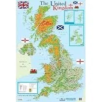
United Kingdom Map (70x100)
Description
The “United Kingdom Map (70x100)” is a large-format educational wall map displaying the UK and its regions, ideal for classrooms, offices, or libraries at 70×100 cm.
Map Content Overview
Title: United Kingdom Map
Size: 70×100 cm (excellent for large-group teaching and geographic reference)
Key Map Features:
Clearly marked boundaries of England, Scotland, Wales, and Northern Ireland
Major regions and counties highlighted (e.g., Yorkshire, Cornwall, West Midlands, Highlands)
Major cities: London, Edinburgh, Cardiff, Belfast, Manchester, Birmingham, Glasgow, Liverpool, Bristol, Newcastle
Capitals of each country emphasized
Key rivers (Thames, Severn, Clyde, Trent) and lakes (Loch Ness, Windermere, Lough Neagh)
Major roadways, railways, airports, and ferry connections
Seas and channels: Irish Sea, North Sea, English Channel, Atlantic Ocean
Insets (optionally) showing detail or urban regions (London, Manchester, Edinburgh metropolitan areas)
Educational Use
Valuable for geography and history lessons, travel planning, or political studies, showing regions, cities, transport, and physical features.
Designed to maximize readability with clearly labeled features, visual differentiation of regions, and useful map symbols.
For print:
High-resolution, color-coded maps with legend and scale for accurate reference
Customizable for bilingual labeling, physical/political overlays, lamination, or additional symbols as needed.
Specifications
| Model No. | N-C146 |
|---|


