
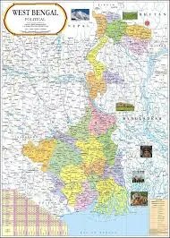
West Bengal Physical Map (70x100cm)
Description
The “West Bengal Physical Map (70x100cm)” is a large, laminated educational wall chart that highlights the diverse physical geography of West Bengal, featuring rivers, plains, mountains, delta, forests, and other natural features. It is widely used for classrooms, exam preparation, and public displays.
Physical Specifications
Size: 70 × 100 cm, ensuring clear and detailed visualization for group study and classroom teaching.
Material: Multicolour printing on high-quality map litho or photographic paper, with hot-sealed lamination for durability and easy cleaning; most charts have rollers for hanging.
Map Content and Features
Shows major landforms including:
The Himalayan hill region (Darjeeling area in the north)
Terai and Dooars regions at the Himalayan foothills
Vast Gangetic plains covering central and southern West Bengal
The Sundarbans mangrove delta and coastal plain in the south.
Clearly marks significant rivers (Ganga/Hooghly, Teesta, Damodar, Subarnarekha) and their tributaries, wetlands, and key lakes.
Labels forest areas, wildlife sanctuaries (Sundarbans, Jaldapara), highlands in the west (Rarh and Chota Nagpur plateau fringe), and elevation zones with color coding.
Indicates state boundaries (Jharkhand, Odisha, Bihar, Sikkim, Assam), international borders (Bangladesh, Nepal, Bhutan), and major urban centers (Kolkata, Siliguri, Asansol, Darjeeling) for orientation.
Equipped with a legend, contour/elevation shading, and concise facts to support lessons and exam prep.
Used for teaching about agro-climatic regions (deltaic, alluvial, rain-shadow areas) and water resources.
Classroom and Educational Use
Ideal for geoscience, environmental studies, topography, river basin and delta analysis, and practical map exercises.
Supports exam preparation (UPSC, WBCS, SSC) by providing real, syllabus-aligned visuals of landforms and physiographic units.
The durable size and finish allow frequent reference, use in mapping activities, and clarity for entire classrooms.
This chart is fundamental for visualizing and understanding the rich physical geography and environment of West Bengal.
Specifications
| Model No. | N-C324 |
|---|


